
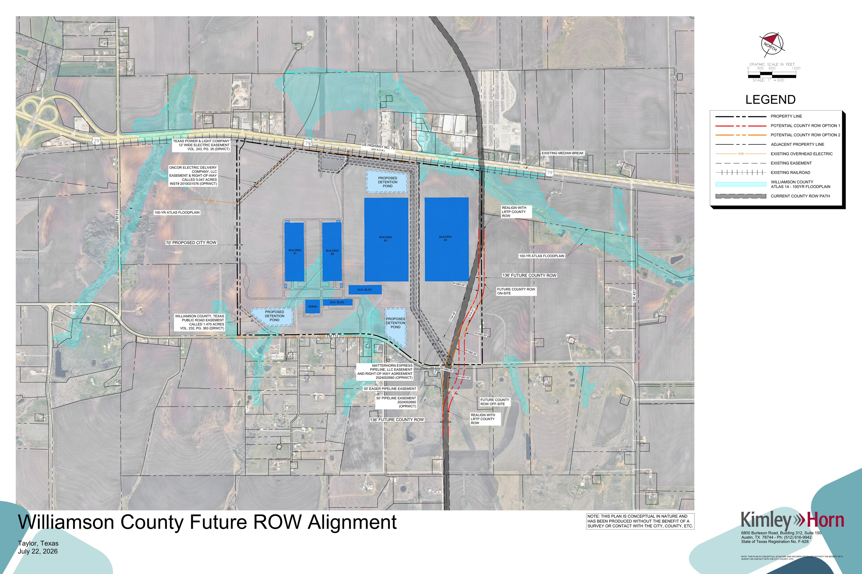
Newly obtained Williamson County public records provide the clearest public look yet at how the massive Project Mustang data-center campus east of Taylor could be organized — and reveal that the developer and County have been discussing alternatives to a future County roadway planned along the project's eastern side.
The July 22 exhibit, prepared by Kimley-Horn during coordination with Williamson County infrastructure staff, depicts four large conceptual data-center buildings, administration and auxiliary structures, three detention ponds, floodplain areas, railroad infrastructure and major electric and pipeline easements across the approximately 664.572-acre Project Mustang site.
Two proposed County roadway alternatives
The exhibit shows the County's existing long-range transportation corridor along with two alternative 136-foot County right-of-way alignments. The alternatives appear intended to navigate site constraints including the U.S. 79 connection, pipeline/electric easements, floodplain conditions and nearby development.
The drawing also shows a separate 70-foot proposed City right-of-way on the western side of the property.
Records summarized by ProjectMustangTX.org show that Williamson County asked Kimley-Horn to provide a more detailed exhibit depicting the existing and proposed rights-of-way, aerial context, floodplain limits, north/south connections and roadway geometry designed around a 45-mph standard. Kimley-Horn returned the revised two-option exhibit on July 22.
What the map shows about the campus
Beyond the roadway issue, the exhibit provides a broader visual context for the proposed industrial campus. It depicts four major data-center footprints and multiple infrastructure constraints across a site bordered by FM 112, railroad infrastructure and large utility corridors.
The map is important because other Project Mustang materials have repeatedly described the project layout as conceptual and subject to later engineering. This drawing adds detail, but it does not establish the final location of every building, generator, substation, storage area or other facility.
No County approval shown
The currently published records do not show Williamson County approving either alternative road alignment.
Correspondence indicates that Kimley-Horn continued seeking County feedback after the July 22 submission, including follow-up communications later in July and early August. The exhibit therefore documents an active planning discussion — not a final County decision.
Questions the new records raise
The newly public exhibit makes several questions more concrete:
- Will Williamson County alter its long-range roadway plan to accommodate Project Mustang?
- Which alignment, if any, does the County ultimately prefer?
- Who would dedicate and pay for the 136-foot right-of-way and eventual roadway?
- What portion of construction or future maintenance would become a public responsibility?
- How will the corridor connect north and south of the property?
- What improvements will ultimately be required at FM 112 and U.S. 79?
- How will the final Traffic Impact Analysis affect the conceptual road plan?
Why this matters
Project Mustang is not only a private land-development question. A project of this scale can influence long-range transportation planning, utility infrastructure, emergency access and future development patterns outside its property boundaries.
When a private project proposes changes to planned public infrastructure, residents should be able to see what is being proposed, what government staff have been asked to consider, who would bear the cost and whether a change primarily serves the public transportation network, the private development, or both.
This is exactly where public-records reporting matters: the new Williamson County production lets residents see a planning discussion that previously existed largely inside agency and consultant correspondence.
What happens next
Project Mustang is advancing through Taylor's Employment Center and annexation process. The project covers parcels R006648 and R006650, totaling approximately 664.572 acres, and is proposed as a closed industrial campus containing data-center, electrical and on-site power-generation infrastructure.
Wilco Liberty Project will continue following the City and County approval process and will update this story if Williamson County adopts, rejects or materially revises either proposed road alignment.
Sources
- ProjectMustangTX.org — Traffic & Roadway Coordination ↗
- ProjectMustangTX.org — Project Overview & Records ↗
This article is original Wilco Liberty Project reporting and analysis based on newly released Williamson County records and the linked Project Mustang documentation. Proposed or conceptual features are identified as such.