
TAYLOR, Texas — Before debating emission rates or air-quality models, Project Mustang raises a simpler question: where will its power-generation equipment actually sit in relation to the people who already live around it?
The proposed campus covers about 664.572 acres immediately east of Taylor on Williamson Central Appraisal District parcels R006648 and R006650. Although Project Mustang is commonly described as a data-center development, the current concept also calls for an enormous private power system built to serve those data centers: about 1,040 megawatts of on-site generation, potentially using dozens of natural-gas generating units, along with substations, diesel backup systems, gas infrastructure and other industrial equipment.
That scale is one reason a Taylor planning commissioner described the proposal at the Aug. 18 hearing as a “power plant with a data center attached.” The phrase was a commissioner’s characterization, not an official project designation, but it captures an important part of the public-policy question: Project Mustang is not simply a set of server buildings drawing electricity from the existing grid. Its current concept includes a major on-site generation complex as a core part of the development.
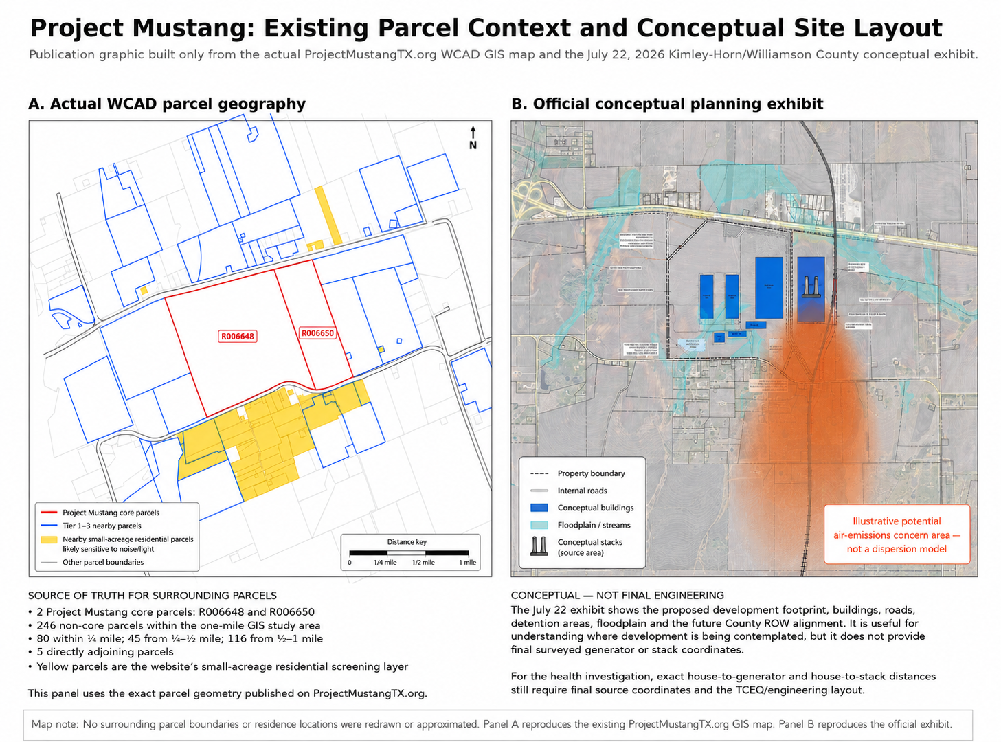
On a regional map, 665 acres can look isolated. A parcel-level view shows something different.
WLP’s GIS analysis identified 246 non-project parcels within one mile of the combined Mustang boundary. Of those, 80 are within one-quarter mile, 45 are between one-quarter and one-half mile, and 116 are between one-half mile and one mile. Residentially classified parcels directly adjoin portions of the project, with a notable concentration south and southeast near FM 112 and CR 446.
Some residential parcel boundaries are only tens to low hundreds of feet from the Mustang property line.
That does not mean a house will sit tens of feet from a generator or stack. It means the distance that matters most has not yet been established publicly.
The Aug. 18 hearing showed why location matters
At the Aug. 18 Taylor Planning & Zoning hearing, Project Mustang representatives described an initial concept of about 1,040 megawatts of on-site generation supporting roughly 700 MW of data-center load. The generation system could include approximately 84 to 112 natural-gas generating units, with discussion of both gas turbines and reciprocating engines.
Other disclosed components included diesel backup generators, black-start generation, battery-energy storage, substations, a gas yard, urea and fuel-related storage, and large cooling or mechanical systems. Gas-generation stacks could reach approximately 125 feet.
Those disclosures provide a much clearer picture of the project’s industrial scale. They still do not establish the final location of each generator, stack or support facility inside the 665-acre site.
That is where the GIS analysis and the conceptual site plan meet. WLP can identify the residential parcels surrounding Mustang and show where the current planning exhibit places major development areas. What cannot yet be calculated is the final distance from an occupied home to a particular stack, gas-generating unit or diesel source.
That distinction matters because Mustang’s acreage leaves substantial room to move equipment within the site. A generation yard placed deeper inside the property could be much farther from a particular residence than the same equipment placed near an exterior boundary.
Why a 125-foot stack is not enough information
Stack height alone does not tell a nearby resident what concentration of a pollutant could reach ground level at a home.
EPA’s AERMOD regulatory modeling system uses source characteristics and meteorology to estimate concentrations at specific receptors. Inputs can include source location, emissions, stack dimensions and exhaust characteristics, while terrain, weather and building effects can alter how a plume disperses.
That also means the closest house is not automatically the location with the highest modeled concentration. Depending on wind and atmospheric conditions, a plume can remain elevated near a source and reach higher ground-level concentrations farther away.
The useful question is therefore not simply, “How tall is the stack?” It is: What reaches each occupied residence under the range of conditions the project is expected to experience?
The south and southeast stand out — but wind changes
The FM 112–CR 446 area deserves close attention because of the concentration of residential parcels near Mustang’s southern and southeastern boundary. Residential properties also exist on other sides of the project.
But WLP is not labeling one neighborhood as the inevitable “downwind” area. Central Texas wind direction changes with weather and season. Serious dispersion modeling evaluates many hours of meteorological conditions rather than drawing one prevailing-wind arrow.
For a final health analysis, verified occupied homes should be treated as individual receptors. The useful measurement is the distance from each residence to the nearest major generation area, exhaust stack, diesel-generator area, BESS, substation, gas yard and applicable chemical or fuel-storage area.
What could be emitted — and what WLP cannot yet determine
Natural-gas turbines and engines can emit pollutants including nitrogen oxides, carbon monoxide, particulate matter and volatile organic compounds. EPA also identifies stationary combustion turbines as sources of hazardous air pollutants such as formaldehyde, benzene and acetaldehyde. Nitrogen oxides and VOCs can also contribute to ground-level ozone formation.
Those are established characteristics of combustion equipment generally. They are not evidence that Project Mustang will expose nearby residents to harmful concentrations.
WLP cannot yet calculate project-specific concentrations at any residence because the necessary engineering and emissions inputs have not been publicly established.
What is known
- About 665 acres.
- About 1,040 MW in the current generation concept.
- Roughly 84–112 gas-generating units discussed.
- Diesel backup and black-start generation disclosed.
- Stacks could reach about 125 feet.
- Residential parcels exist close to portions of the project boundary.
What is still missing
- Final turbine/engine models and unit count.
- Exact generator and stack coordinates.
- Final house-to-source distances.
- Hourly and annual emissions.
- Final air-permit application.
- Project-specific dispersion-modeling results.
A setback is not the same thing as source distance
Taylor has discussed setbacks and other protections through the Employment Center process. Those rules matter, but a setback from a project boundary or building does not automatically tell a resident how far a bedroom, porch or backyard will be from the equipment producing emissions.
Project representatives and the city could resolve much of that uncertainty with one public exhibit: a dimensioned source-and-receptor map showing the distance from nearby occupied residences to the major generation, diesel, electrical and chemical-support facilities.
That exhibit should distinguish final surveyed locations from conceptual or estimated ones and be updated when the site plan changes.
What can be answered now — and what cannot
Some of the most important details needed for a true source-to-residence air-quality analysis are unlikely to be available until Project Mustang advances much further through engineering and environmental permitting.
That includes the final generation layout, exact stack coordinates, specific turbine or engine models, emissions rates, operating schedules and the detailed modeling files that would be used in a TCEQ air-permit review.
In other words, the public may not get the information needed to calculate actual exposure at nearby homes for some time.
That does not make the current questions premature. It makes the conceptual stage especially important, because decisions about where generation equipment, stacks, diesel systems and other industrial components are placed could eventually determine which existing homes are closest to the project’s major emission sources.
For now, the responsible conclusion is narrower: WLP can identify where residential properties are located around Project Mustang and where major industrial areas are conceptually shown. It cannot yet determine what pollutant concentrations would reach those homes.
That answer will require project-specific engineering and air-permitting data that does not yet exist publicly.
Part 2 will examine the pollutants associated with Mustang’s proposed natural-gas and diesel generation, what is known about their health effects, and what project-specific data is still needed before anyone can credibly describe the risk to nearby homes.
Sources
- City of Taylor — PZ 2026-2715 / Project Mustang
- Project Mustang — parcel GIS map
- Wilco Liberty Project GIS analysis of Williamson Central Appraisal District parcel geometry
- U.S. EPA — AERMOD preferred and recommended models
- U.S. EPA — Stationary Combustion Turbines / hazardous air pollutants